

The Brief
While commercial operators and drone manufacturers fixate on proposed 14 CFR Part 108 to normalize Beyond Visual Line of Sight (BVLOS) flight, the real economic architecture is quietly unfolding in an adjacent docket: proposed 14 CFR Part 146. Embedded in the FAA’s August 2025 Notice of Proposed Rulemaking (Docket FAA-2025-1908), Part 146 establishes a federal certification framework for a new category of commercial enterprise: Automated Data Service Providers (ADSPs).
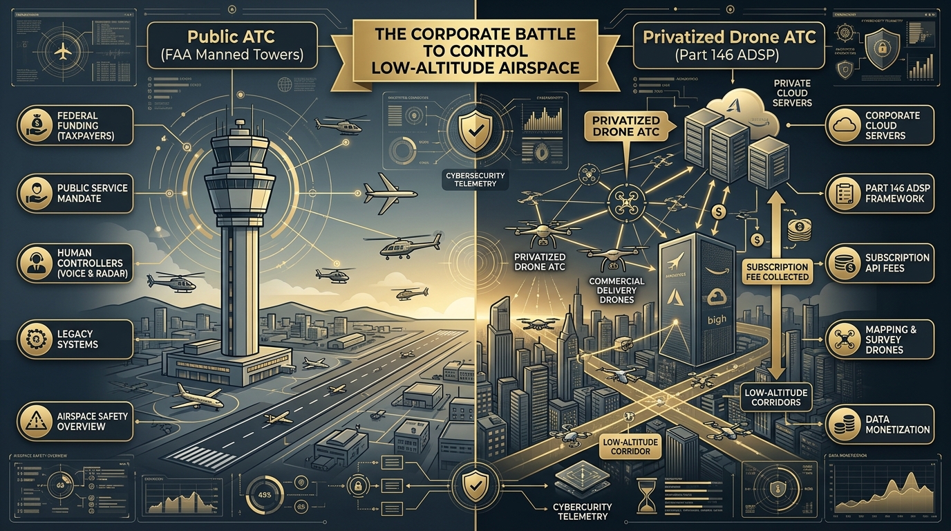
Under the proposal, air traffic control below 400 feet will not be managed by FAA controllers in airport towers. Instead, it will be outsourced to private software platforms handling strategic deconfliction, conformance monitoring, and real-time flight telemetry routing. For commercial flight leads, this creates a profound structural reality: routine BVLOS will not merely require an airworthy aircraft and a remote pilot certificate—it will mandate a paid commercial subscription to an algorithmic gatekeeper.
Imagine if every time you drove your truck onto a road, an automated camera scanned your vehicle and billed your credit card $4.00 for "digital corridor access."
If you wanted to avoid the fee, your only choice would be to stay parked in your driveway.
That is the economic model quietly taking shape for the future of commercial drone flight.
Ask most drone pilots about the future of commercial aviation, and they will point to Part 108. They are waiting for the day when the FAA drops the requirement for human visual observers, ends the agonizing case-by-case waiver backlog, and lets automated aircraft inspect pipelines or deliver packages across entire metropolitan areas.
What few operators have studied is the recurring software bill attached to that future: proposed 14 CFR Part 146.
In traditional aviation, air traffic control is a public service. When an airliner or a flight student in a Cessna takes off, the federal government provides radar separation, weather advisories, and runway sequencing. It is paid for through aviation fuel taxes and federal budgets. Federal air traffic controllers do not swipe your credit card every time they sweep their radar over your transponder.
At 200 feet above a city, however, the FAA’s legacy radar network is blind. Federal towers cannot manually talk to 10,000 package delivery drones, real estate cameras, and mapping rigs darting between buildings and over power lines.
The FAA's solution is not to build thousands of new radar towers or hire an army of federal controllers.
Instead, the agency is preparing to outsource low-altitude air traffic control to private tech corporations under Part 146.
The Evolution: From Temporary Waivers to Permanent Monopoly
For the last several years, the FAA tested digital drone routing through provisional experiments called the Near Term Approval Process (NTAP). Companies like Wing, Zipline, and SkyGrid received temporary letters allowing them to route their own aircraft.
But NTAP had a major legal limitation: every approval was glued directly to a single company’s specific waiver. If the waiver expired, the software lost its clearance.
Proposed Part 146 changes the rules completely.
Under Docket FAA-2025-1908, the FAA proposes creating a permanent, standalone certification for Automated Data Service Providers (ADSPs). This turns data providers into an official regulatory class—like an airline or a certified repair station—directly regulated by the government, completely separate from the drone manufacturers.
To earn FAA certification under Part 146, a software provider must meet demanding technical requirements, heavily anchored in industry consensus standards like ASTM F3548-21:
- Strategic Deconfliction (The Digital Reservation): The software must mathematically prove that two flight paths will not cross in 4D space—meaning latitude, longitude, altitude, and exact time of day—before either aircraft leaves the ground.
- Conformance Monitoring (The Digital Leash): The software must monitor live telemetry to confirm an aircraft stays within its approved airspace block, sounding automated alarms if it wanders 50 feet off course.
- Aviation-Grade Cybersecurity: The cloud architecture must be shielded against signal spoofing, data injection, and distributed denial-of-service (DDoS) attacks that could blind a city's low-altitude corridors.
- Black-Box Audit Trails: Every flight plan, trajectory change, and telemetry ping must be permanently recorded and searchable for federal investigators following any near-miss or crash.
How the Tollbooth Operates in the Real World
An ADSP is not a smartphone app you download to check the wind before flying. It is an enterprise cloud computing engine that connects directly to the FAA’s national airspace feeds, tracks manned airplanes, and talks to thousands of drones at once.
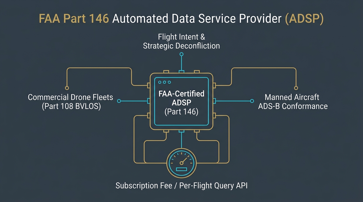
If you plan to fly an out-of-sight commercial mission under proposed Part 108, your preflight routine will no longer be just checking propellers and airspace maps:
- Submitting Flight Intent: Your ground station software sends your planned flight path—down to the exact GPS coordinates, altitude, and minute-by-minute timeline—to your certified ADSP.
- The Algorithmic Gate: The ADSP checks your path against every other active drone flight, emergency helicopter route, and weather hazard. If a delivery company already reserved that corridor five minutes ahead of you, your flight request is programmatically rejected or rerouted.
- Live Conformance: In the air, your drone must continuously feed GPS coordinates back to the ADSP over cellular or satellite. If your aircraft loses link or drifts outside its digital corridor, the ADSP automatically alerts surrounding aircraft to steer clear.
If your aircraft loses connection to its ADSP, you are out of conformance—and legally grounded.
The Corporate Battle for the Sky
This technical mandate creates an enormous commercial prize: whoever owns the ADSPs controls access to low-altitude commercial aviation.
Big Tech platforms, major telecommunications carriers, and defense software contractors are already positioning themselves to become the dominant ADSPs in the country. By placing themselves directly between the drone pilot and the sky, ADSPs will be able to monetize every single commercial flight through API query charges, monthly software subscriptions, or per-mile corridor access fees.
For an international retail giant running hundreds of automated grocery deliveries an hour, paying an automated toll is an insignificant cost of doing business.
For an independent Part 107 operator, however, the math looks very different:
- The Overhead Squeeze: An independent pilot who only needs to fly out-of-sight twice a month for a utility survey could face the same hefty enterprise software retainers as a multi-million-dollar logistics fleet.
- Platform Fragmentation: If Client A requires you to use Provider X's software, but the municipality you are flying in contracts with Provider Y, flight leads could be forced to juggle multiple expensive subscriptions and complex API logins.
- Interoperability Failures: Proposed Part 146 mandates that competing ADSP systems share data with each other in real time. If Company A’s software takes two seconds too long to notify Company B’s software about an incoming drone, who is held liable when two aircraft meet in midair?
The most critical takeaway for working pilots is simple: Part 146 does not apply to visual-line-of-sight flights. If you are flying a mapping or photography job where you keep the drone in your own sight under Part 107, the sky remains open and toll-free.
The moment you want to fly beyond visual line of sight, however, the digital tollbooth will be waiting.
Flight-Ready Breakdown
Airspace ArchitectureWhat Changed
The FAA’s proposed BVLOS rulemaking bundles Part 146 alongside Part 108. Part 146 establishes the certification, cybersecurity, and operational standards for third-party Automated Data Service Providers (ADSPs) to manage low-altitude traffic routing, replacing temporary NTAP letters with a permanent corporate regulatory class.
Who is Affected
Commercial flight departments preparing for routine BVLOS transitions, UTM software vendors, avionics developers, and enterprise program leads budgeting for future fleet flight-management software stacks.
Why it Matters
Air traffic control for drones will not be a free public service provided by FAA towers. It will operate as a privatized digital utility, creating recurring SaaS subscriptions, API query fees, and compliance costs for every commercial BVLOS flight.
Before Next Mission
Fly your current Part 107 jobs under existing rules; visual-line-of-sight flights do not require an ADSP link. If your organization is modeling 2027 fleet budgets for BVLOS expansion, build commercial UTM subscription retainers and per-flight API transaction costs into your cost-per-flight-hour calculations.
What Not to Assume
Do not assume Part 146 is final law today—it remains a proposed rule in executive review alongside Part 108. Do not assume FAA air traffic controllers will manage drone corridors. Do not assume consumer mobile apps will qualify as certified ADSPs. Do not assume standard Part 107 flights will be forced to pay ADSP fees.
Sources
- • Federal Aviation Administration: Notice of Proposed Rulemaking: Normalization of Commercial Beyond Visual Line of Sight Operations (Parts 108 and 146), Docket FAA-2025-1908 — https://www.regulations.gov/docket/FAA-2025-1908
- • Federal Register: 14 CFR Part 146 (Proposed), Certification and Operations: Automated Data Service Providers, 90 FR 38212 — https://www.federalregister.gov/
- • ASTM International: ASTM F3548-21: Standard Specification for UAS Traffic Management (UTM) UAS Service Supplier (USS) Interoperability — https://www.astm.org/f3548-21.html
- • FAA UAS Traffic Management (UTM): Concept of Operations v2.0 & Architecture Guidelines — https://www.faa.gov/uas/research_development/traffic_management
The Drone Pilot Brief does not accept payment for editorial coverage.

Related Briefs

California’s 400-Foot Stadium Drone Bill Reaches the Governor: What It Means for Event Airspace
California lawmakers passed AB 2113, establishing a $500 fine for flying within 400 feet of outdoor concerts and sporting events. With Governor Newsom facing a September 30 deadline, the bill reignites the legal battle over federal airspace preemption....

Gravity for U.S. Military Drone Operator Assessment
USNDA and OUSW(R&E) establish National Drone Wars as the central venue for evaluating U.S. military drone operator proficiency, signaling a major shift in UAS modernization, procurement, and doctrine....
Why Your Drone Can’t Legally Fly on 5G (And How 200 Aircraft Just Cracked the Wall)
The FCC granted a temporary nationwide waiver for DOT’s Mobile Network Aviation Assessment Program. It bypasses decades of cellular airborne restrictions across 14 spectrum bands — but Part 107 pilots cannot fly on it yet....
Get The Preflight
The weekly operational-intelligence briefing for drone pilots. Filtered down to what actually matters before your next mission.