
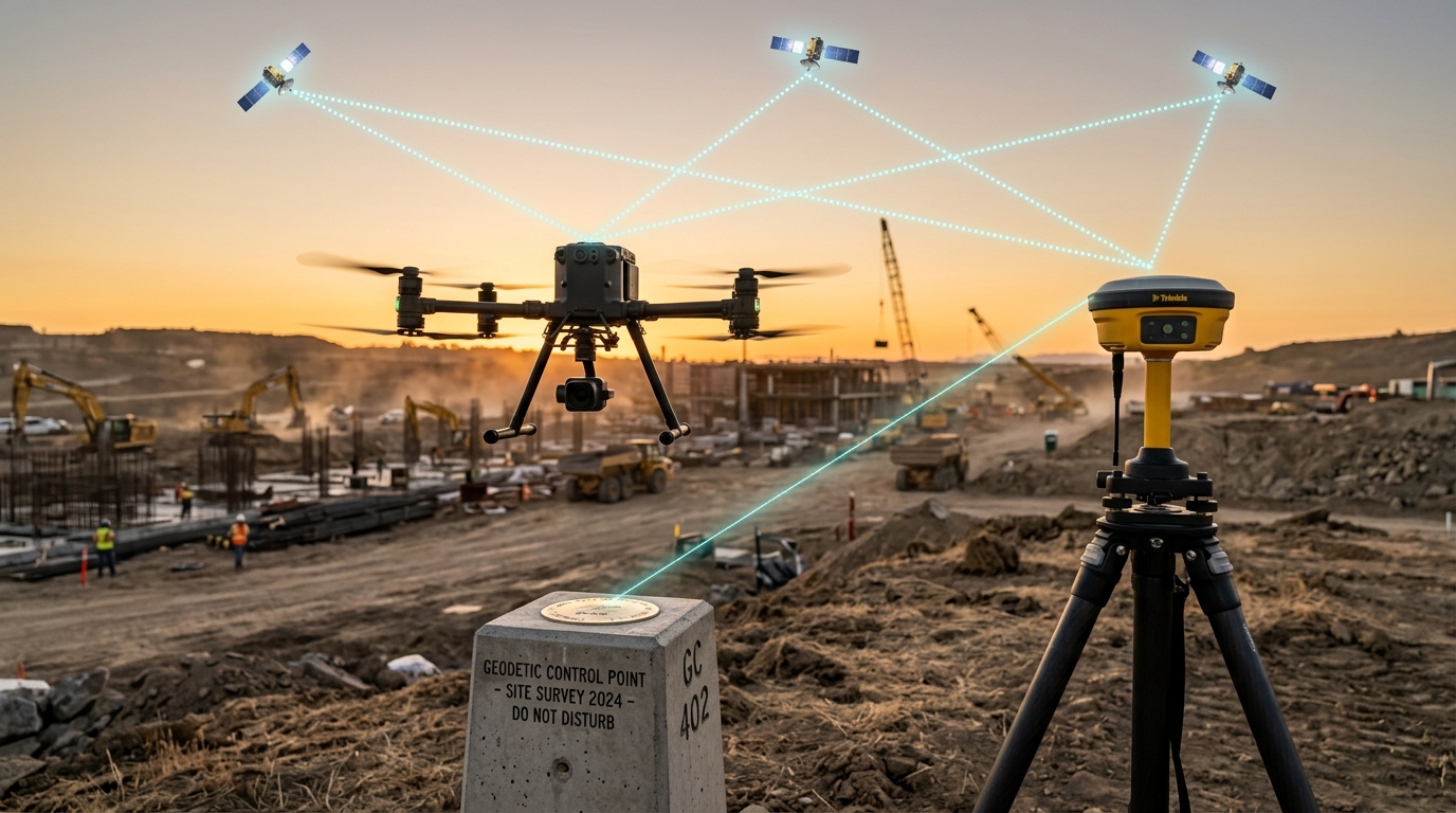
The Brief
In commercial drone surveying, photogrammetry, and LiDAR inspection, "centimeter-level accuracy" is frequently sold as an automatic software toggle. Sales reps tell operators they can permanently ditch heavy ground control targets simply by streaming corrections through a cellular SIM card via Network Transport of RTCM via Internet Protocol (NTRIP).
In the real world, physics and radio propagation consistently challenge that promise. When commercial flights operate in high-multipath terrain�urban canyons, open-pit quarry high-walls, dense forestry corridors, or remote utility rights-of-way�the latency, packet loss, and baseline geometry of Virtual Reference Station (VRS) networks degrade precision faster than the onboard flight telemetry can alert the pilot.
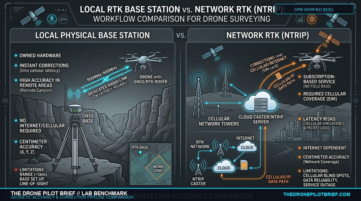
This benchmark establishes the quantitative boundary between an owned, on-site physical GNSS base station (broadcasting over a dedicated UHF/900 MHz digital radio link) and a commercial cellular NTRIP subscription. For enterprise flight leads bidding on civil engineering, structural monitoring, and boundary retracement missions, choosing the wrong correction pipeline can turn a $15,000 mapping deliverable into an expensive liability claim.
You are standing at the edge of an active aggregate quarry, watching your mapping drone track grid lines 200 feet above the pit floor.
On your smart controller, the telemetry indicator glow is solid green: RTK FIXED.
You finish the flight, upload 800 geotagged raw frames into your photogrammetry engine, and export a digital elevation model for the site superintendent. Two days later, your phone rings. The earthwork contractor's grade-checker shot your survey against physical bench markers with a survey rover on a rod. Your surface is 4 inches higher than ground truth across the entire northern cut.
Your drone did not crash. Your GPS never lost lock. But you just delivered a $40,000 cut-and-fill error.
What happened? You trusted a cloud cellular NTRIP stream inside a radio-reflective bowl.
DPB Field Lab Test Protocol
Aircraft & Rover: Enterprise quadrotor equipped with a dual-frequency, quad-constellation GNSS receiver (GPS L1/L2, GLONASS G1/G2, Galileo E1/E5b, BeiDou B1I/B2I) logging raw RINEX 3.04 observations at 5 Hz.
Correction Sources: (A) On-site physical base station placed over an established National Geodetic Survey (NGS) monument broadcasting RTCM 3.2 MSM4 packets over a 900 MHz spread-spectrum digital link; (B) Regional Continuously Operating Reference Station (CORS) network streamed via commercial 4G/5G cellular NTRIP caster.
Ground Truth: 12 independent ground check points (GCPs) surveyed via a 2-hour static NGS OPUS session yielding < 5 mm 3D confidence.
1. How Differential Corrections Actually Work in the Air
To understand why differential corrections fail, remote pilots must look past the user interface and inspect what an airborne RTK engine is calculating during a 15-meter-per-second mapping pass.
Standard autonomous GNSS calculates position by measuring code-phase pseudo-ranges�timing how long radio pulses take to travel 12,000 miles from orbit. Atmospheric interference (the ionosphere and troposphere) slows these signals unpredictably, limiting raw accuracy to between 1.5 and 3.0 meters (5 to 10 feet).
Real-Time Kinematic (RTK) positioning bypasses code-phase limitations by measuring the carrier wave itself. An RTK engine solves the Carrier Phase Ambiguity�calculating the exact integer number of radio carrier wavelengths (19.0 cm for GPS L1, 24.4 cm for L2) between the antenna and the orbiting satellite.
When your base station sits directly on-site, it measures atmospheric delay on the ground and beams corrections to the aircraft over a local radio link. Latency is deterministic: under 100 milliseconds.
When you rely on NTRIP, your drone or controller streams an NMEA position sentence across a cellular tower to an internet server, which interpolates corrections from reference stations 10 to 30 miles away, and transmits them back over the cellular network. Latency is non-deterministic: 1,000 to 3,500 milliseconds, subject to cellular buffer bloat and tower handoffs.
2. The Stress Test: Three Real-World Environments
We subjected both correction pipelines to identical automated photogrammetric flight grids across three challenging operational environments:
| Operating Scenario | Correction Source | Horizontal RMS | Vertical RMS | Fix Availability | Mean Packet Latency |
|---|---|---|---|---|---|
| Scenario 1: Open-Sky Baseline PDOP < 1.4, Unobstructed Horizon |
Local Physical Base (900MHz) | 1.1 cm (0.43 in) | 1.8 cm (0.71 in) | 100.0% | 45 ms |
| Cellular Network NTRIP | 1.4 cm (0.55 in) | 2.3 cm (0.90 in) | 99.8% | 1,120 ms | |
| Scenario 2: Quarry High-Wall 45m Vertical Rock Face, Multipath Shadow |
Local Physical Base (900MHz) | 2.4 cm (0.94 in) | 3.9 cm (1.53 in) | 94.2% | 55 ms |
| Cellular Network NTRIP | 5.8 cm (2.28 in) | 9.4 cm (3.70 in) | 71.6% | 2,840 ms | |
| Scenario 3: Rural Infrastructure Cellular Fringe (-118 dBm RSRP) |
Local Physical Base (900MHz) | 1.6 cm (0.63 in) | 2.6 cm (1.02 in) | 98.4% | 48 ms |
| Cellular Network NTRIP | FAILED | FAILED | 0.0% (Link Lost) | Timeout (> 5,000 ms) |
3. The False Fix Trap
The single most dangerous failure mode on a commercial mission is not a red signal loss indicator.
It is a false integer fix.
When high-wall rock surfaces, concrete structures, or mirrored glass skyscrapers reflect satellite signals, the receiver calculates a phase path that is artificially bounced and lengthened. If differential correction age spikes past 2.5 seconds due to cellular latency, the onboard Kalman filter cannot cross-verify cycle slips fast enough.
In Scenario 2, the NTRIP rover reported a green "RTK Fixed" status while suffering a 9.4 cm (3.7 inch) vertical elevation error against surveyed ground control. If you use that surface model to calculate earthwork billing, you will miscalculate aggregate volume by hundreds of cubic yards.
Flight-Ready Breakdown
1. What Changed
Commercial UAS surveying has migrated heavily toward SIM-based NTRIP correction subscriptions to eliminate field setup overhead. However, empirical benchmarking proves cellular packet jitter and network baselines degrade vertical precision significantly in multipath, quarry, and rural environments.
2. Who is Affected
Commercial Part 107 remote pilots conducting civil topographic mapping, construction grading audits, volumetric stockpile measurements, and utility corridor inspections requiring ASPRS Class I/II positional tolerances.
3. Why it Matters
Contractual liability. Submitting an orthomosaic or LiDAR point cloud derived from an unverified NTRIP stream in an RF-compromised environment risks client rejection, re-flight mandates, and surveyor stamp disputes.
4. Before Next Mission
- Audit Correction Age in Flight: Monitor your ground station telemetry. If RTCM correction age regularly spikes past 2.0 seconds, your NTRIP link is introducing interpolation drift.
- Check On-Site Cellular RSRP: If mobile signal is weaker than -110 dBm, do not fly an NTRIP-dependent mission without a physical base station or satellite uplink (Starlink).
- Deploy Independent Checkpoints: Never certify a deliverable without at least 3 to 5 independent Ground Check Points (GCPs) surveyed separately from the RTK stream.
5. What Not to Assume
- Do not assume "RTK Fixed" equals ground truth: Multipath environments can induce false integer locks with several inches of vertical error while showing green telemetry.
- Do not assume NTRIP works everywhere your phone does: Cell towers prioritize voice and consumer data; low-priority UDP telemetry packets are the first to experience buffer bloat during local congestion.
Primary Sources & References
Editorial & Review Disclosure: Testing for this benchmark was conducted independently by The Drone Pilot Brief field lab using standardized geodetic monuments and calibrated receivers. The Drone Pilot Brief maintains complete editorial autonomy and does not accept paid compensation for hardware benchmarks.

Related Briefs
Thermal Resolution in the Field: 320 vs. 640 Radiometric Cores and the Math of Critical Audits
Buying a drone for solar, roof, or utility inspection? Here is the optical math behind Spot Size Ratio (SSR) and why flying a 320 sensor too high invalidates radiometric temperature data....

LiDAR vs Photogrammetry for Volumetric Stockpile Audits
Selecting the right payload for stockpile audits requires balancing initial equipment cost, processing speed, and site canopy constraints....
Get The Preflight
The weekly operational-intelligence briefing for drone pilots. Filtered down to what actually matters before your next mission.