The Brief
In commercial drone thermography�whether scanning utility-scale solar farms, auditing commercial flat roofs for trapped moisture, or inspecting high-voltage substations�payload pricing creates an immediate fork in the road. A dual-sensor thermal drone equipped with an entry-level 320×240 uncooled microbolometer often costs $3,500 to $5,000, while an enterprise aircraft sporting a 640×512 radiometric core routinely commands $8,000 to $14,000.
Sales reps frequently tell prospective buyers that lower resolution simply requires "flying a little lower." In the field, however, physics, flight battery limits, and international inspection standards (such as IEC 62446-3 for photovoltaic arrays) tell an unforgiving story.
This operational guide breaks down the optical math behind Instantaneous Field of View (IFOV) and Measurement Spot Size Ratio (SSR). Understanding this formula is the difference between delivering certified, actionable radiometric reports and having your deliverables thrown out by insurance adjusters and warranty engineers.
Imagine using an optical thermometer to check a patient�s temperature from across the room, but the sensor�s lens is so wide that it averages the patient�s forehead with the cold air conditioning unit behind them.
The patient has a 104�F fever. Your thermometer reads 98.6�F.
That is exactly what happens when you fly an uncalibrated 320-resolution thermal drone across an industrial asset. You aren�t reading the hotspot; you are reading a blurred average of the hotspot and the cool aluminum framing next to it.
The 3×3 Measurement Rule
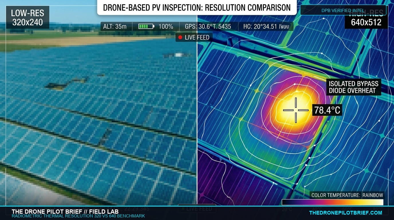
A thermal sensor pixel can detect an anomaly with 1 pixel (Detection IFOV). However, to accurately measure true radiometric temperature (Measurement IFOV / MFOV), the target anomaly must completely cover a minimum of 3×3 contiguous pixels on the detector core to eliminate background optical bleed.
The Optics: Calculating Maximum Flight Ceiling
Consider a standard utility solar inspection. A defective bypass diode, junction box fault, or micro-crack hotspot on a photovoltaic module typically occupies an area of approximately 30 mm × 30 mm (1.2 × 1.2 inches).
Using a standard 13mm thermal focal length:
- 640×512 Radiometric Core (12μm pixel pitch): Produces an IFOV of ~0.92 mrad. To project 3×3 pixels across a 30mm target, your maximum allowable Above Ground Level (AGL) altitude is 36 feet (11 meters) for certified temperature measurement. For detection (1-pixel classification), you can fly up to 110 feet (33 meters).
- 320×240 Core (12μm pixel pitch): Produces an IFOV of ~1.85 mrad. To project 3×3 pixels across that same 30mm hotspot, your maximum flight ceiling drops to 18 feet (5.5 meters).
The Real-World Penalty: Flight Time and Collision Risk
Flying a 20-megawatt solar farm or a multi-acre commercial rooftop at 18 feet AGL is practically untenable. At 18 feet, your aircraft is operating below light poles, fence lines, and inverter structures, creating severe obstacle collision risks.
More importantly, the narrower field of view forces you to fly four times as many flight grid passes, multiplying battery cycles, field labor, and pilot exhaustion by 400%.
When an operator flying a 320 sensor cheats and flies at 80 feet to save time, the 30mm hotspot covers only a fraction of a single pixel. The sensor averages the 85°C diode hotspot with the surrounding 35°C glass. The report reads an innocuous 44°C�masking a critical electrical fire hazard and invalidating the solar warranty claim.
Flight-Ready Breakdown
1. What Changed
Sub-$5,000 thermal drones have democratized aerial infrared. While capable for search and rescue or macro wildfire tracking, 320x240 sensors cannot satisfy quantitative ASTM and IEC inspection standards on small electrical targets without flying dangerously low.
2. Who is Affected
Commercial drone service providers bidding on solar farm audits, commercial flat roof moisture surveys, building envelope commissioning, and utility distribution line inspections.
3. Why it Matters
Data defensibility. Engineering firms, asset owners, and warranty underwriters require radiometric deliverables that adhere to recognized thermal resolution thresholds. Submitting smeared data damages firm credibility.
4. Before Next Mission
- Calculate Your MFOV: Measure the expected defect size (e.g., cell hotspot, roof seam, insulator pin) and verify your flight altitude ensures at least a 3x3 pixel footprint.
- Perform NUC Calibration: Always perform Non-Uniformity Correction (NUC) after reaching operating altitude to eliminate detector thermal drift.
- Check Emissivity Settings: Ensure emissivity (ε) and reflected apparent temperature are configured in the metadata before logging radiometric R-JPEG files.
5. What Not to Assume
- Do not assume a visible hotspot means an accurate temperature: Pixel averaging will dramatically understate peak temperatures unless the target fills the measurement spot size.
- Do not assume digital zoom improves thermal resolution: Digital 2x/4x zoom interpolates pixels; it does not add optical data or increase radiometric accuracy.
Primary Sources & References
Editorial & Review Disclosure: Testing for this guide was conducted independently by The Drone Pilot Brief field lab. The Drone Pilot Brief maintains complete editorial autonomy and does not accept paid compensation for hardware reviews or payload ratings.

Related Briefs
The Commercial GNSS Benchmark: Local RTK Base Stations vs. Network NTRIP in High-Multipath Environments
Before you trust centimeter deliverables to a cellular SIM card, understand where Network RTK quietly drifts. Here is the field-tested performance boundary between dedicated tripod base stations and cloud NTRIP casters....

LiDAR vs Photogrammetry for Volumetric Stockpile Audits
Selecting the right payload for stockpile audits requires balancing initial equipment cost, processing speed, and site canopy constraints....
Get The Preflight
The weekly operational-intelligence briefing for drone pilots. Filtered down to what actually matters before your next mission.