Key terms
- FAA: Federal Aviation Administration, the U.S. agency that runs civil aviation and the airspace.
- Drone / UAS: UAS means unmanned aircraft system: a drone plus the equipment used to fly it. FAA notices say "UAS."
- TFR: temporary flight restriction. Airspace the FAA closes to some or all aircraft for a set time.
- NOTAM: Notice to Airmen, the FAA's official name since Feb. 10, 2025. An official FAA notice pilots must check before flying. TFRs are published as NOTAMs.
- FDC NOTAM: a NOTAM from the FAA's Flight Data Center. The FAA uses this type for regulatory notices, including TFRs.
- NM: nautical mile, about 1.15 regular miles (1.85 km).
- AGL: above ground level. Height measured from the ground under the drone, not from sea level.
- UTC: Coordinated Universal Time, the single clock aviation uses worldwide.
- CBP: U.S. Customs and Border Protection, part of DHS (the Department of Homeland Security). CBP decides who may fly in the border band.
- LAANC: Low Altitude Authorization and Notification Capability. App-based FAA approvals for Part 107 flights in controlled airspace near airports.
- Part 107: the FAA rule for commercial and other non-hobby drone flying. Pilots under it hold a Remote Pilot Certificate, the FAA certificate earned by passing the Part 107 knowledge test.
- CFR / U.S.C.: the Code of Federal Regulations (rules written by agencies) and the United States Code (laws passed by Congress). "14 CFR 99.7" means Title 14, Section 99.7.
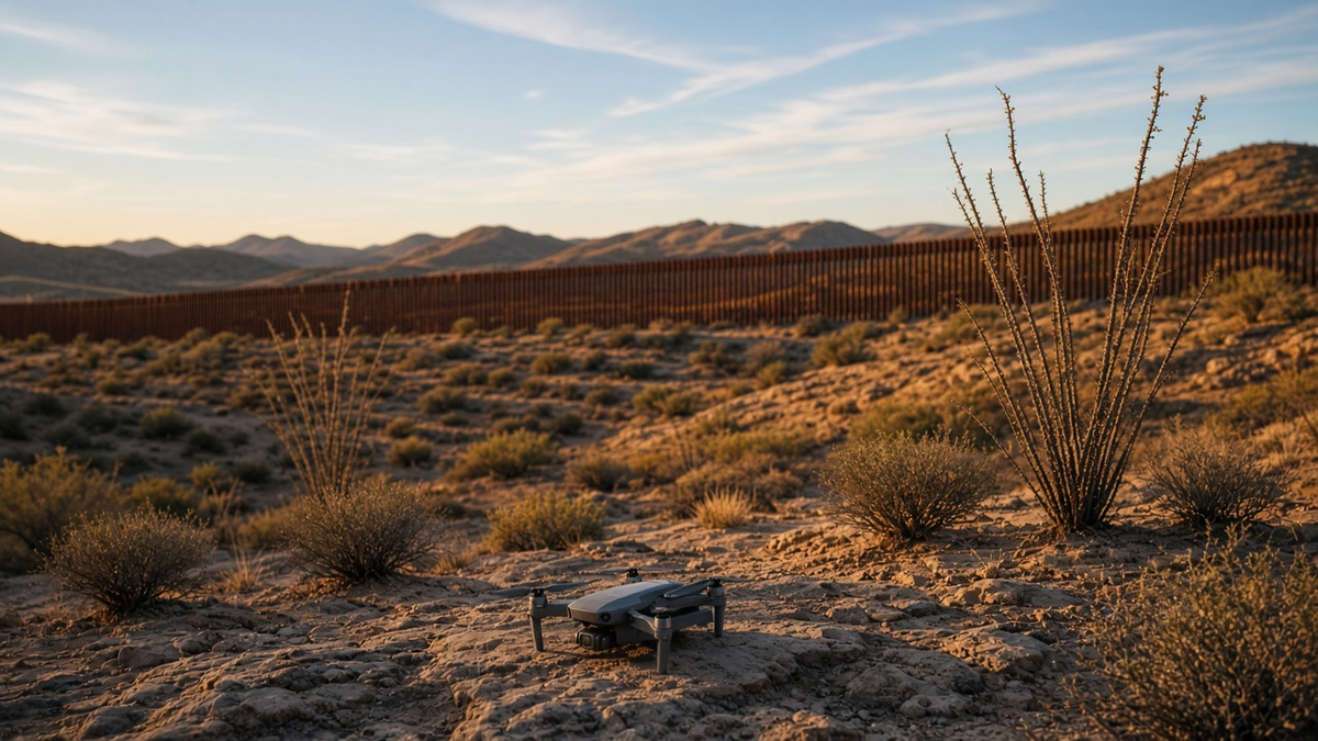
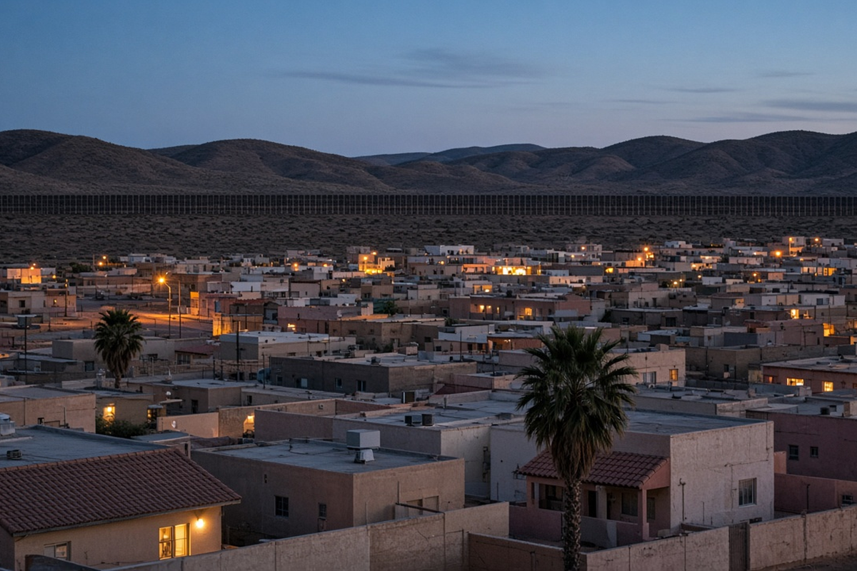
- AI-generated: made with an artificial intelligence (AI) image tool. Our photo illustrations are labeled this way; they don't show real places, aircraft models or people.
- National defense airspace: airspace the FAA sets aside "in the interest of national defense" under 49 U.S.C. 40103(b)(3). The NOTAMs abbreviate it "NTL defense airspace."
Say you've got a roof inspection Tuesday morning on the south side of town. The house is a few blocks from the border fence. You've flown this neighborhood before. Your planning app looked clean last week.
Check again. As of Tuesday, Oct. 20, the FAA's temporary flight restriction list at tfr.faa.gov still didn't show the border restriction, which took effect Monday evening. The NOTAMs that create it are live in the FAA's NOTAM system, and together they run the whole line from the Pacific to the Gulf.
Here's what the FAA's text says, what it doesn't, and what you can't assume.
What changed
On Friday, Oct. 16, the Department of Transportation (DOT), the Department of War (DoW) and the Department of Homeland Security (DHS) announced a temporary flight restriction for drones along the southern border. A temporary flight restriction, or TFR, is a block of airspace the Federal Aviation Administration (FAA) closes to some or all aircraft for a set period.
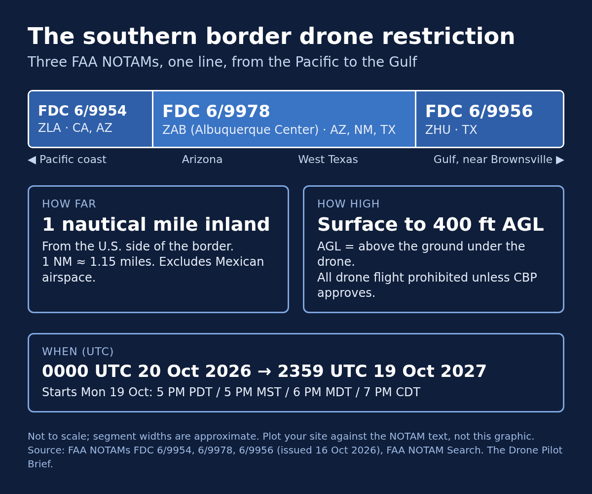
The binding terms aren't in the press release. They're in three NOTAMs. A NOTAM, or Notice to Airmen, is an official FAA bulletin pilots must check before flying. Each of the three says that under 14 CFR 99.7 (Title 14 of the Code of Federal Regulations, Section 99.7), all drone flight is prohibited within 1 nautical mile inland from the U.S. side of the border, from the surface to 400 feet AGL (above ground level), excluding Mexican airspace.
Plain English on the limits:
- 1 nautical mile (NM) is about 1.15 regular (statute) miles, or about 1.85 km. It's measured inland from the border.
- Surface to 400 feet AGL means from the ground up to 400 feet above ground level. That covers the same airspace most Part 107 flights already work in.
The three NOTAMs split the border among three FAA Air Route Traffic Control Centers, usually just called "Centers." These are large regional FAA facilities that provide air traffic control, mainly to aircraft flying between airports. Each NOTAM is an FDC NOTAM, issued through the FAA's Flight Data Center, the type the FAA uses for regulatory notices like TFRs:
- FDC 6/9954, Los Angeles Center (ZLA): California and Arizona, from the Pacific coast east
- FDC 6/9978, Albuquerque Center (ZAB): Arizona, New Mexico and Texas
- FDC 6/9956, Houston Center (ZHU): Texas, east to the Gulf
The FAA's Domestic Notice, its plain-language companion document, has a map of all three. It also says the map "is provided for situational awareness only."
When it took effect: Monday evening, not last Friday
The release called the TFR "effective today," meaning Oct. 16. The NOTAMs say otherwise. All three are headed "OCTOBER 19, 2026-OCTOBER 19, 2027 LOCAL." All three are effective from 0000 UTC Oct. 20, 2026 until 2359 UTC Oct. 19, 2027. (UTC, Coordinated Universal Time, is the world-standard clock aviation uses. 0000 is midnight; 2359 is 11:59 p.m.)
On the ground, it took effect Monday, Oct. 19, at:
- 5 p.m. PDT (Pacific Daylight Time) in California
- 5 p.m. MST (Mountain Standard Time) in Arizona
- 6 p.m. MDT (Mountain Daylight Time) in New Mexico and El Paso
- 7 p.m. CDT (Central Daylight Time) in the rest of Texas
It ends on Oct. 19, 2027, at 4:59 p.m. Pacific and Arizona time, 5:59 p.m. Mountain and 6:59 p.m. Central.
The NOTAMs govern. The release itself said the FAA "will publish a NOTAM," and the Domestic Notice tells pilots to "refer to the published NOTAMs for complete restriction details, including effective dates and times."
One number in early reports isn't in the FAA system
If you saw "6/9955" for the Albuquerque section, that was the number in early reporting and on an earlier copy of the FAA's notice. It isn't in the FAA's NOTAM system now. A search of the system as of Sunday, Oct. 18, found no 6/9955. The Albuquerque NOTAM is FDC 6/9978.
There's a second trap. NOTAM numbers get reused. As of Tuesday, Oct. 20, looking up 6/9978 on tfr.faa.gov returned a June 2026 VIP restriction over Santa Ana, California. (VIP is the FAA's category for TFRs that protect the movement of a very important person.) Looking up 6/9956 returned a July 2026 VIP restriction over Morristown, New Jersey. Neither has anything to do with the border. The border NOTAMs were all issued on Oct. 16, 2026, so check the issue date on anything you pull.
Who it reaches
The NOTAMs say "all UAS flight," meaning every unmanned aircraft. That means everyone flying a drone inside the band:
- Part 107 pilots. Real estate, roof and insurance work, survey and mapping, agriculture, utilities, and media.
- Recreational flyers. These are hobby pilots flying under the FAA's separate recreational rules. They must pass The Recreational UAS Safety Test (TRUST) and carry proof of completion. The NOTAMs don't carve out hobby flights or small drones.
- Public-safety teams in border counties in California, Arizona, New Mexico and Texas.
One nautical mile reaches into several border cities. If you work in places like El Paso, Laredo, Brownsville, Nogales or Calexico, check your job address against the NOTAM's line. Don't eyeball the map.
How you get in: CBP, 48 hours ahead, and only for certain flights
Access runs through U.S. Customs and Border Protection (CBP), the DHS agency that runs the ports of entry and the Border Patrol. It doesn't go through the FAA. Under the NOTAMs, a drone flight can be authorized only with prior CBP coordination and approval, and only if it falls into one of two categories:
- It's in direct support of an active national defense, homeland security, law enforcement, firefighting, medevac (medical evacuation, such as air ambulance flights), search-and-rescue or disaster-response mission, or
- It's in support of "event ops." That's the NOTAMs' shorthand; "ops" means operations.
It must also have CBP's approval before the flight and comply with all other FAA rules.
The NOTAMs don't define "event ops." Notice what isn't on the list: routine commercial jobs like real estate, inspection or mapping, and recreational flying. If you think your flight fits a category, ask CBP. Don't assume it does.
Requests go to SWBDRONEZONEWAIVERS@CBP.DHS.GOV at least 48 hours before the flight. They must include:
- Operator name
- FAA certifications
- Phone number
- Flight date, time and location
- Drone details: Remote ID (the drone's broadcast identification; see below), make, model and serial number
Remote ID is, in the FAA's words, "the ability of a drone in flight to provide identification and location information that can be received by other parties through a broadcast signal."
For emergencies, the NOTAMs give first responders a CBP line: 951-570-4185.
Neither the NOTAMs nor the Domestic Notice says how fast CBP will answer. If you book border-area jobs, tell clients the timeline is CBP's, not yours.
What the NOTAMs say about violations
Each NOTAM classifies the band as "NTL defense airspace": national defense airspace, under 49 U.S.C. 40103(b)(3). That law lets the FAA set aside areas of airspace "in the interest of national defense." It's a security label the FAA can put on airspace. Here's what the NOTAMs say it means for pilots who don't comply.
Pilots who don't comply "may be intercepted, detained and interviewed" by law enforcement or security personnel. The NOTAMs list three further possible actions:
- (A) FAA administrative action, including civil penalties (fines) and suspension or revocation of airman certificates (FAA pilot certificates)
- (B) criminal charges, including under 49 U.S.C. 46307, the federal law titled "Violation of national defense airspace"
- (C) deadly force against the aircraft, if it is determined to pose an imminent security threat
Separately, the NOTAMs warn that under 10 U.S.C. 130i and 6 U.S.C. 124n, the Department of Defense (DoD), DHS or the Department of Justice (DOJ) may interfere with, seize or destroy a drone deemed a credible threat. These are the federal counter-drone laws. Both are titled "Protection of certain facilities and assets from unmanned aircraft." (The NOTAMs use the name Department of Defense; the FAA release uses Department of War.)
That's the text. We aren't adding to it.
Why the government says it's doing this
The release says the restriction will "reduce risks to ongoing border security operations, protect federal personnel, facilities and the Homeland, and enhance enforcement against those who violate the restrictions." DHS Secretary Markwayne Mullin said it will "help counter cartel drone threats." Secretary of War Pete Hegseth said "our warfighters will shoot down any cartel drone that threatens America's sovereignty."
Read that last quote for what it says. It is about cartel drones. It isn't a policy statement about licensed pilots. The rules that apply to you are the NOTAM text above.
What not to assume
- LAANC doesn't get you in. LAANC (Low Altitude Authorization and Notification Capability) is the app-based system that clears Part 107 flights in controlled airspace near airports. That's airspace where air traffic control (ATC) manages traffic. The NOTAMs require prior CBP approval.
- An existing waiver doesn't cover it. A waiver is, in the FAA's words, "an official document issued by the FAA which approves certain operations of aircraft outside the limitations of a regulation." A Part 107 waiver, or an approval for some other TFR, isn't CBP approval for this band.
- The usual FAA emergency lane isn't the route. For most TFRs, the FAA points pilots to its Special Governmental Interest (SGI) process, its expedited approval process for flying in a TFR. For this band, the NOTAMs send first responders to CBP's line.
- An empty map isn't a green light. As of Tuesday, Oct. 20, the band still wasn't on the FAA's TFR list or in the FAA's drone airspace data feed. The FAA's TFR page says LAANC apps and B4UFLY (the FAA's app for recreational flyers) display TFRs. That only helps once the data loads. The NOTAM is what binds you.
- The new band doesn't replace older border TFRs. Separate security TFRs are already active near Calexico, California (through Jan. 2, 2027), and around Brownsville, Texas (through Dec. 31, 2026). Some of them reach higher than 400 feet and list their own points of contact. Our read, not a stated FAA rule: CBP approval for the band wouldn't clear you into those.
- Don't read meaning into "event ops." The NOTAMs don't define it.
- Keep checking. The NOTAMs tell operators to check NOTAMs frequently, at tfr.faa.gov or 1800wxbrief.com (a pilot briefing website the NOTAMs name).
Before your next border-area job
- Pull FDC 6/9954, 6/9978 and 6/9956 from FAA NOTAM Search. Confirm the Oct. 16, 2026 issue date.
- Plot the job site against the NOTAM's line, not the Domestic Notice picture.
- If you're inside the band, check whether your flight fits one of the two CBP categories. If it doesn't, the NOTAM gives you no path in.
- If it does, email CBP at least 48 hours ahead with all five required items. Don't fly until you're approved.
- Check for the older border security TFRs too.
Fact vs. interpretation: the dates, times, limits, NOTAM numbers, exception categories, request requirements and penalty language come from the FAA NOTAM text (FAA NOTAM Search, retrieved Oct. 18). They are backed by the FAA release and Domestic Notice linked below. The note on older TFRs is our interpretation.
Sidebar: Stadiums and big events are a different rulebook
This sidebar is not part of the border restriction. The border NOTAMs and the stadium NOTAM both use 14 CFR 99.7, but they are separate NOTAMs with different limits and different people to ask. §44812 is a separate law.
Fall Saturdays bring a different kind of drone restriction. There are two of them, and they're easy to mix up.
1) The standing stadium restriction (14 CFR 99.7 / FDC 0/0367).
14 CFR 99.7 is a short federal regulation. It says pilots in defense areas must follow "special security instructions issued by the Administrator in the interest of national security." The FAA uses it to run a permanent, nationwide stadium NOTAM, FDC 0/0367. Its formal name is "special security instructions (SSI) for select sporting events." The text, pulled from tfr.faa.gov:
"ALL MANNED AND UNMANNED AIRCRAFT OPERATIONS ARE PROHIBITED EXCEPT AS SPECIFIED BELOW WITHIN AN AREA DEFINED AS: 3 NMR OF A QUALIFYING STADIUM OR OTHER SPORTING VENUE HOSTING A QUALIFYING EVENT UP TO AND INCLUDING 3000FT AGL."
In plain English: around a qualifying event (timing below), all aircraft, crewed or uncrewed, are prohibited within a 3-nautical-mile radius ("3 NMR") of the stadium, up to 3,000 feet above ground level, unless an exception applies.
Qualifying means a venue with "a seating capacity of 30,000 or more" hosting a regular- or post-season Major League Baseball (MLB) game, National Football League (NFL) game or NCAA Division One football game, or a NASCAR Cup, IndyCar or Champ Series race. (NCAA is the National Collegiate Athletic Association, which runs college sports. NASCAR is the National Association for Stock Car Auto Racing.) The restriction runs "one hour before the scheduled start until one hour after the end." It applies to model aircraft too. You won't see a new TFR posted for each game. This one NOTAM covers them all.
Getting in means FAA approval through an airspace security waiver (a written FAA permission) at waivers.faa.gov, for operations supporting the event or for the broadcast rights holder. Or it means air traffic control (ATC) authorization for the narrow purposes the NOTAM lists. The NOTAM names the FAA System Operations Support Center (SOSC) as its point of contact and coordination facility: 202-267-8276.
2) Drone-only TFRs for large public gatherings (49 U.S.C. 44812).
49 U.S.C. 44812 is a federal statute. It tells the FAA to "temporarily restrict unmanned aircraft operations over eligible large public gatherings" when an eligible entity asks. The key terms, from the statute:
- Who asks: "a credentialed law enforcement organization of the Federal Government or a State, local, Tribal, or territorial government."
- When: "not less than 30 calendar days prior to the eligible large public gathering."
- What qualifies: an open-air stadium or venue that has previously hosted events under the stadium security instructions, with "an estimated attendance of at least 30,000 people." Or any other gathering of "at least 100,000 people" that is "primarily outdoors" with "a defined and static geographical boundary."
- Public notice: the FAA must publish it "at least 2 days prior to the start."
- Who may fly inside: only operations the FAA authorizes for operational or safety purposes, or safety, security or compliance oversight, or "with the approval of the eligible entity."
These show up as individual NOTAMs. Here's one in effect this week, Oct. 20–24, FDC 6/9095 at Circleville, Ohio: "PURSUANT TO 49 U.S.C. SECTION 44812 AS AMENDED BY SECTION 935 OF THE FAA REAUTHORIZATION ACT OF 2024 FOR PROTECTION OF LARGE PUBLIC GATHERINGS. UAS FLT OPS ARE PROHIBITED WI AN AREA DEFINED AS 1NM RADIUS … SFC-400FT AGL … DUE TO THE CIRCLEVILLE PUMPKIN SHOW." (NOTAM shorthand: UAS FLT OPS = drone flight operations; WI = within; SFC = surface.) Your contact is the named local police point of contact, not CBP.
How to keep them straight:
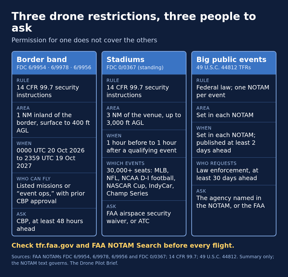
| Border band | Stadium special security instructions (FDC 0/0367) | §44812 event TFR | |
|---|---|---|---|
| Authority | 14 CFR 99.7 (FDC 6/9954, 6/9978, 6/9956) | 14 CFR 99.7 | 49 U.S.C. 44812 |
| Size | 1 nautical mile inland from the border, surface to 400 ft above ground level | 3 nautical miles, up to 3,000 ft above ground level | Set in each NOTAM |
| When | 0000 UTC Oct 20 2026 – 2359 UTC Oct 19 2027 (took effect Mon Oct 19, 5–7 p.m. local) | 1 hour before to 1 hour after qualifying events | Set in each NOTAM |
| Ask | CBP, at least 48 hours ahead (listed missions or "event ops" only) | FAA waiver or air traffic control | The requesting law enforcement agency |
None of these replaces the others. Check tfr.faa.gov and FAA NOTAM Search for every flight.
Sources
Primary:
- FAA NOTAM Search: FDC 6/9954 (ZLA), 6/9978 (ZAB), 6/9956 (ZHU), retrieved Oct. 18, 2026. https://notams.aim.faa.gov/notamSearch/
- FAA press release, "DOT, DoW, DHS Join Forces to Protect Southern Border Airspace," 16 Oct 2026. https://www.faa.gov/newsroom/dot-dow-dhs-join-forces-protect-southern-border-airspace
- FAA Domestic Notice DOM26047, dated Oct. 16, 2026. https://www.faa.gov/air_traffic/publications/domesticnotices/dom26047_gen.html
- FAA TFR list. https://tfr.faa.gov/
- 1800wxbrief.com, pilot briefing website (named in the NOTAMs). https://www.1800wxbrief.com/
- FAA, Temporary Flight Restrictions for drones. https://www.faa.gov/uas/getting_started/temporary_flight_restrictions
- FDC 0/0367, stadium special security instructions. https://tfr.faa.gov/tfr3/?page=detail_0_0367
- 14 CFR 99.7 (eCFR, the Electronic Code of Federal Regulations). https://www.ecfr.gov/current/title-14/chapter-I/subchapter-F/part-99/subpart-A/section-99.7
- 49 U.S.C. 44812 (LII, Cornell Law School's Legal Information Institute). https://www.law.cornell.edu/uscode/text/49/44812
- FDC 6/9095, Circleville, Ohio, §44812 TFR. https://tfr.faa.gov/tfr3/?page=detail_6_9095
- Existing border-area security TFRs: FDC 6/2657 (Calexico, California) https://tfr.faa.gov/tfr3/?page=detail_6_2657 ; FDC 5/3679 (Brownsville, Texas) https://tfr.faa.gov/tfr3/?page=detail_5_3679
- Number-reuse examples, seen on tfr.faa.gov, Oct. 18, 2026: FDC 6/9978 (June 2026 VIP TFR, Santa Ana, California) and FDC 6/9956 (July 2026 VIP TFR, Morristown, New Jersey). Both had expired.
- FAA, LAANC. https://www.faa.gov/uas/getting_started/laanc
- FAA, Remote ID. https://www.faa.gov/uas/getting_started/remote_id
- FAA, Certificated Remote Pilots (Part 107). https://www.faa.gov/uas/commercial_operators
- FAA, Recreational Flyers. https://www.faa.gov/uas/recreational_flyers
- 49 U.S.C. 40103 (LII). https://www.law.cornell.edu/uscode/text/49/40103
- 49 U.S.C. 46307 (LII). https://www.law.cornell.edu/uscode/text/49/46307
- 10 U.S.C. 130i (LII). https://www.law.cornell.edu/uscode/text/10/130i ; 6 U.S.C. 124n (LII). https://www.law.cornell.edu/uscode/text/6/124n
- FAA, Part 107 Waivers. https://www.faa.gov/uas/commercial_operators/part_107_waivers
- FAA, Air Route Traffic Control Centers (facility list). https://www.faa.gov/about/office_org/headquarters_offices/ato/service_units/air_traffic_services/atc-facilities
- FAA, Aeronautical Information Manual, Chapter 5, Section 1 (FDC NOTAMs; Flight Data Center). https://www.faa.gov/air_traffic/publications/atpubs/aim_html/chap5_section_1.html
- FAA Order 7930.2U, "Notice to Airmen (NOTAM)," effective June 9, 2025 (NOTAM name). https://www.faa.gov/documentLibrary/media/Order/7930.2U_Basic_w_Chg_1_dtd_8_10_25_NOTAM.pdf

Related Briefs
What Your Drone's Remote ID Actually Broadcasts, and Who Can Tie It to You
Anyone with a phone app nearby can see your drone's ID number and where you're standing (or where you took off). Your name isn't in the signal. Linking that number to you runs through the FAA....
Part 108 is still under White House review. Here's what a Part 107 crew can do now.
The FAA's long-awaited rule for flying drones beyond sight isn't law yet. These seven steps use rules you already fly under, and none of them depend on guessing the final text....

The Digital Tollbooth: Inside Proposed Part 146 and the Corporate Battle to Control Low-Altitude Airspace
While the drone industry watches Part 108, the real business model is quietly unfolding in proposed Part 146. Here is how Automated Data Service Providers will gate, monitor, and monetize low-altitude commercial flight....
Get The Preflight
The weekly operational-intelligence briefing for drone pilots. Filtered down to what actually matters before your next mission.